

 Explore Jammu Province
- Jammu District
- Doda
- Kishtwar District
- Rajouri District
- Poonch District
- Reasi District
- Udhampur District
- Ramban District
- Kathua District
- Samba District


Explore Jammu Province
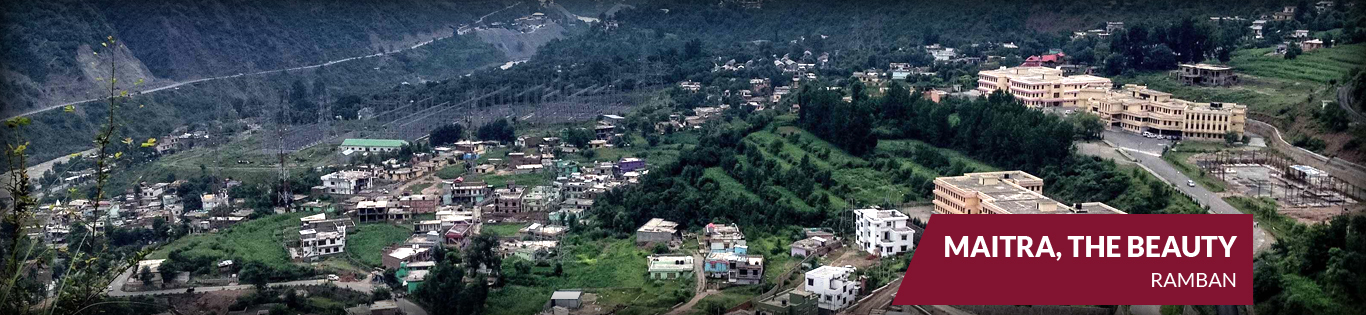
Ramban District
Ramban at a Glance
Ramban is one of the newly carved out districts of Jammu and Kashmir state which came into being on 01-04-2007 after the erstwhile Doda district was further split into three districts of Ramban,Kishtwar and Doda .The boundary lines of the district stand drawn with the famous hill resort of Patnitopon its south, Assar on its east,Gool on its west and Banihal on its north District Ramban shares its boundary with Reasi, Udhampur, Doda, Anantnag and Kulgam. District Ramban consists of six tehsils (Ramban, Banihal, Pogal, Paristan, Gool, Batote),Ten.Ramban town which is the district headquarter is located along the river Chenab also known as “chanderbagha” on the national highway 44 which passes through the district and connectsJammu and Srinagar cities .The Ramban town is located at 33*14`N and 75*17`E longitude at an altitude of 1000 meters and situated at a distance of 150kms from Jammu making it almost the central point on the national highway.More Information
| Altitude | 1000 meters |
| Temperature | |
| Varies according to the altitude.in Ramban town it rises as high as 42°C in summer,but in the adjoining areas such as Banihal, Gool, Pogal-Paristan and Batote is temperate with pleasant summer and harsh winter. | |
| Best Season | March to May and October. |
| Clothing | Summer: Light Clothing to Light Warm. Winter: Warm Clothing/woolens to Full Warm |
| Food | The faviroute dish of the region which is popular throughout the Country viz Rajma-Chawal with Desi Ghee and Anardana Chatni at the place “Peerah” on NHW |
Getting There
How to Reach Ramban
By Road:-The Ramban district is situated on National highway in the mid of two cities Jammu and Srinagar.the daily services such as Tempo traveller, coaches,busies and taxis are plying from both side Jammu and Srinagar.By Flight:-The nearest airport is in Jammu and Srinagar.
By Rail:-The nearest station is Banihal just 40kms via Srinagar and another station is Udhampur 70kms.
Accommodation: A number of Hotels & Guest Houses are available suiting every ones Budget.
What to see in Ramban District
The tourism potential places of Ramban district:
Banihal at a Glance:Banihal has always been known as the gateway connecting Jammu and Srinagar which was made famous by the 2.5km long Jawahar tunnel and now the Banihal-Qazigund rail tunnel [India’slongest and the third longest in Asia]. Another four lined tunnel is under-construction, now in finalstages. Banihalislocated at an average elevation of 1666m (5466ft) and situated at a distance of about 30km from district headquarter and 37 km from Qazigund town of Anantnagdistrict. According to “Rajtarangni” (meaning the ‘waves of king’)-a chronicle penned by Kashmiri historian Kalhana that recorded political history and heritage of Kashmir and its kingdoms and the kings till the 12th century, Banihal was known as ‘Vishalta’in the 11th century and was a very narrow mountainousvalley which was used as an escape route by revolting princes, rebels,chieftains and conspirators from Kashmir.Banihal in Kashmiri language mean ‘blizzard’ and the area has perhaps derived its name from the treacherous weather of Banihal pass which is situated at an elevation of 2832m (9291ft) on Pir-panchal mountain range and connects Banihal with Qazigund on other side of the mountain. The Pir-panchal mountain range separatesKashmir valleyfrom the Himalayas and plains of the south. The pass is accessible only in summer and remains closed for rest of the year due to heavy snowfall. In 11th century, a small fort existed below the old Banihal pass called the ‘Bansalla’.The Bansalla fort belongedto the 11th century ruler of Vishalta-Khasa lord Bhagika who was son-in-law of lord Buddhal-Tikka.
Climate:
Banihal is closely surrounded by rock andSnow Mountains and temperature in winter dips as low as 10 degrees centigrade.In Banihal, the weather is temperate with pleasant summers and harsh winters.
The terrain of the area is hilly with nearly 96% of the population is rural based; depending mostly on rain fed agriculture. Crops and vegetables:The principle crops are maize,rice, pluses, etc. Also fruits like apple,walnut,apricot,pear and vegetables like pumpkin,turnip,cucumber,chilli,onion, spinach etc. are grown in different areas of the Banihal vicinity.
Railway Station Banihal:
It is situated in Halqapanchayat of Tehsil Banihal. It was commissioned on 26th June 3013 and passenger trains run from Banihal to Baramullah. The station has been built as part of the Kashmir railway mega project intending to link the Kashmir valley and Jammu tawi and rest of the Indian railway network. The station also features Kashmiriwood architecture with an intended acme of a royal court which is designed to complement the local surrounding to the station.
Tourism potential:
The Banihal station is rising up as tourist hub day by day. The vicinity of the station has provided opportunities of adventure and herbal Tourism. The Pir-panchal range has variety of herbs which are useful for curing numerous ailments.
NilpalLamber:-
This spot is situated at a distance of about 5kms from Railway station Banihal with motor able road. There is a waterfall of about 2m height, sloping gorgeous meadows, spring and flowing rivulet offering an excellent place for picnic. This tourist spot offers opportunity for hiking and snow sledging. From the top one can have a majestic view of entire Banihal area, the four way road tunnel and the famous Banihal pass on the Pir-panchal range on the opposite side.
Thandi-chhah:
This potential Tourist place is about 10kms from Banihal town connected by a motor able road. This scenic spot has two parallel streams flowing on either side of the vast meadows.
Zabban:
The picturesque meadow of Zabban is located about 5kms from the national highway from Nowgammorh.
Neel Top:
This scenic spot is located at a distance of about 55kms from District head quarter Rambanabd 25km from Banihal town via Chamalwas village, at an altitude of nearly 1800-2000 m. It is connected by a motor-able road. Another road to Neel Top is from Magerkote.
How to reach:
One has to take trip form Jammu at about 180kms on National highway to Chamalwas, there leads link road about 18kms to reach the Neel top.
Accommodation:
Presently the only available accommodation is PWD community-cum-Guest House. A helipad is there at the Top. Tourism potential:The area has scenic spots and a vast lush green meadow of several kilometers and one can have a view of snow-cladded mountain peaks of Pir-panchal range,like HANS RAJ PEAK (3998m), besides the panoramic view of Banihal Town and its adjoining areas. It attracts large number of local picnickers during summer. The idyllic beauty of the place offers perfect leisure,pleasure and relaxation for visitors.
Mountaineering:
The popular peak of the area is HANSRAJ PEAK (3998 m). It is situated at Pir-panchal range, about 15kms from Banihal pass on southward direction. This peak is second highest peak of entire district. In summers, this peak is used for mountaineering by locals who are fond of climbing mountains.
Camping:-
Important spots of the vicinity has attraction of every one who want to spent some of their lovely moments at such spots. Camping and night halt on the top of Pir-panchal range is enjoyable during summer season. Some important spots are: Thalan, Yamul-top, Mal-tragan, Vasa-marg, etc.
Trekking:
The potential traditional trekking routes of olden days which are still used by people in summer are:
Hard tracks:
1) Neel Top (base) --------------Wasa-marg-----------Ejan-tragh----------Chang Top-----------Hals-dhar(Kashmir)road connectivity----------Verinag. (Two days)
2) Neel Top-------Wasa-marg---------Ejan-tragh---------Bari-naal-----------Thandi-chhah road connectivity-----------Banihal Town. (One day)
3) Neel Top--------Zaradi--------Devita-dhar----------Wanbara(night halt seasonal local hats available for accommodation)----------Hansraj pass-------Kapran(Kashmir) road connectivity ------------Varinag.(Two days)
4) Neel Top---------Perhinder------------Daganbass-----------Sargali (beautiful plateau best for camping)----------Yamul Top----------Mayalsar(night halt seasonal cottages available, place of leisure, pleasure and relaxation; beautiful natural like is there)---------NaniMarg (on the top of Pir-panchal range, nomads often visit there in summers for grazing their cattles)--------------Kapran(Kashmir) road connectivity----------Varinag (two days)
Soft track:
1) Banihal---Chamalwas ---Neel top. (2 hours)
2) Neel top---vasa-marg. (2hours)
3) Neel top---Maltragan---Gagar-nag top. (3hours)
Pogal-Paristan at a Glance:
Pogal-Paristan is newly carved out tehsil from Tehsil Banihal which came into being in the year 2014. It is situated about 35kms from District headquarter Ramban and 23kms from Banihal town.
The tehsil head quarter is located at Ukhral just 8kms from National Highway via Magarkote.It is totally hilly area and consists of nine revenue villages, i.e., Pogal, Panchal, Alinbass, Paristan, Bingara, Dhanmasta, Sujmatna, Ramsu andSenabhati.
The inhabitants of the area mainly depend upon agricultural activities and used to grow crops of all seasons like Maize, Potatoes, Pluses (Rajma) etc. The area has a potential of horticultural activities.
How to reach:
To visit this area from Jammu station, one has to take road trip. At about 175 kms coverage of NHW to Magarkote, there leads link road to reach the tehsil head quarter (Ukhral). From Ukhral road further leads into three branches which connects Pogal, Paristan and Alinbassareas.
Accommodation:
There are PWD rest House available for accommodation to the visitors. Some local Guest House on Traditional pattern are also avalaible for accommodation of the tourists.
Languages:
Pogali, Kashmiri,Gojri are the main languages of the area.
Arts & Culture:
The sweet song(pogaligeet) locally called ‘Chan’ is pleasant to hear and is sung by men and women on special occasions. The lyrics are mixture of Kashmiri/dogri.
Climate:
Pleasant in summers and harsh cold in winters. The temperature rises as high as 32 degree Celsius in the summer and in winter goes below minus.
Tourism Potential of the areas:
The area provides opportunities for cultural, orchard, agro and adventural tourism potential. The area has scenic spots and vast lush green meadows of several kms such asNani-marg, Mayal-sar, Yamul top,Sargali,Goglidhar(Sunsari),Devhira, sharwadhar are some important spots of Pogal-Paristan Tehsil. There are two main water streams: one flows from Pogalnallah and another from Paristannallah, both met at Ukhral and from there passes through Batroo hamlet and join Magerkote to Bechlari rivulet and finally into mighty river Chenab. In 2015 two macro hydro-electric power projects were sanctioned about two MW each, the work is in progress.
Tourism potential:
It is a promising tourist resort which when exposed to the outside world can make a mark on tourist landscape.This potential tourist spot offers excellent opportunity for adventurous Tourism activities as the area receives heavy snowfall during winter months.The local school children frequently visit the place for picnic and cricket matches. Sargali have best camping ground for trekking amidst beautiful grasslands.
Sharvadhar: The scenic spot ofSharvadhar is located about 30kms from National High Way via Magerkote. The 18kms of the motor able road from Magerkote follows 12kms pony track up to Sharvadhar from Senabati village. The track from Senabati to Sharvadhar is a steep climb through a scenic forest track.
This place is famous for 400 year old Chandi Mata Mandir. Every year a yatra is held in the Mid of June (i.e., in the month of Bikramy “Hara”) and continues for a fortnight. Thousands of throng from adjacent districts and even from outside the state came here to participate in this centuries old yatra.
Gogli-dhar (Sunsaree):
The beautiful landscape ofGogli-dhar(Sunsaree) literally meaning ‘golden rocks’ in Kashmiri is situated about 4kms from Maligam(Pogal) via lower Gogly and about 5kms from Senabati village(Paristan) on foot. The lash green meadows present a pleasing sight. During summers, the habitants of adjoining areas settle here for 4 months along with their livestock.In winter, this place receives heavy snowfall.
Tourism potential:It is best for adventure activities. The trekking routes are:
1)Ukhral—Alinbass—Gogli-dhar. (5hours )
2)Ukhral—Maligamphalsil—Gogli-dhar. (5 hours)
3)Paristan—Gogli-dhar. (1 hours)
This place also offers camping on the top is very enjoyable during summer.
Kharwan:
It is located in Village Dhanmasta Tehsil PogalParistan District Ramban.It is a beautiful plateau situated at a distance of about 5kms from Gugwani (Neel) and 8kms from Batroo via PogalParistan road. Both the routes are pony track. The road is under-construction so far.The Gugwani (Neel) track which passes through pristine forest cover of fir and Deodar trees, meandering stream and rivulets adds more beauty to the place.
Tourism potential:From the plateau of Kharwan, one can have a majestic view of entire Neel and Paristan areas. During Dogra rule a Fort was constructed there named “PogalQilla” but was ruined and now only debris of this monument are there.
One of the famous saints named ‘Johar sahib’ belong from this area. Today he is being remembered by the people of entire district for his spiritual value which Allah had bestowed him. At that time people visited to the saint and their wishes were fulfilled.
Maho-Mangat at a Glance:
Maho village is located at a distance of about 35kms from the Jammu-Srinagar National Highway viaNachalana and about 45kms from Banihal Town. Its tehsil head quarter is Khari just 5kms from National Highway.The Baramulla-Katra rail line is passing through the Khari which is still under construction. Maho-Mangat is bestowed with extremely mesmerizing natural beauty,pristine forest cover of fir and deodar trees,meandering streams and rivulets, huge grassy meadows,snow-cladded mountain peak in the backdrop and is home to unique flora and fauna.To a visitor from outside it appears as God’s hand painted picturesque valley.
How to reach:
One has to go Maho-Mangat from Jammu by road, from Nachlana on National Highway leads link road to reach Maho-Mangat.
Tourism potential:
It is situated at an altitude of 2500 m in the lap of Pir-panchal range.The breathtaking beauty of the place is so captivating that one feels like having an endless vacation here. The people are hospitable though basic tourist infrastructure is still not in place. The Mangat village is further on 2kms track from Maho. The twin villages of Maho-Mangatoffer great opportunities for adventure tourism like mountaineering,etc.
Adventure :
This area provides opportunities for adventurous sports which can be developed, such as: Mountaineering-TheMaho peak locally called “Yard-Bal” (about 4992m in altitude) is highest peak of District Ramban. This peak is covered with snow for almost ten months. Before independence the English men constructed a stay-ward on the top of peak (present till date), which was circular in shape with four feet pillar in mid and made-up of concrete cement. This peak is best for mountaineering activities. The Trekking Route are: -Maho---To---Maho peak(5 hours).
Camping
Camping and night stay is very enjoyable during summer season. Some important spots for camping are:Achan, Doodpaw,Mangat etc. and several spots surrounded of Maho-Mangat.
Trekking:
The area provides opportunities to trekkers. It is an ideal place for sightseeing and trekking on these following routes:
1) Maho (Base) --------------Maho pass---------------Danew-KandyMarg(Kashmir)------------Kulgam (one day).
2) Maho-------------Mangat--------------Jawahar tunnel top-------------Verinag (Kashmir)( one day).
3) Maho-----------------Mangat-------------Nunwan------------------Zabban--------------Nowgam(Banihal) road connectivity.(Half day)
Existing Infrastructures:
The Tourism Department has started the construction of TRC-guest House for accommodation facility to visitors. The Govt.has launched an incentive scheme for conversion of private houses into paying-Guest by which locals will earn their livelihood and boost the tourism from this scheme.The area is electrified by solar energy and drinking facilities are available in the form of tap and natural springs.
Gool at a Glance:
Gool is located 55kms to the west from District head quarter Ramban and is situated at about 1600 meters above from the see level. The town is situated in the lap of lofty mountains, conifer forests and a majestic view of snow-cladded peaks. The temperature in summer rises up as high as 32 degree Celsius, the winter is intense cold in December with snowfall of 5-6 feet recorded at a time.
How to reach:
One has to go Gool from Jammu by road there are two way one road leads via Ramban 190kms from Jammu and another leads via Reasi about 210kms from Jammu to reach the Gool. Accommodation: A number of Hotels and Guest Houses are available suiting every ones budget.
Tourist spots in Gool:-
GhoraGali-
This spot is located at about 0.5 km before the Gool Town and as the name suggest is famous for large stone horse sculptures and stone carved idols strewn around the slope and almost a dozen springs and bolies designed in intricate stone carvings with motifs displayed dating back to several centuries. There are two to three well decorated riders on top of each horse. The local legend is that these have been designed by the pandavas.
Tourism Potential:
Ghora-Gali is of immense Archaeological value. The potential for cultural tourism and the fact that the spot is connected a motor able road from Ramban can make it a potent tourist attraction. The park can be developed into a scenic one through gardens and parks/Floriculture department and the site can be handed over to state Archaeology department for the proper maintenance as a heritage site.
Dogan Top:
Dogan Top is situated about 10kms from Gool on Gool-Mahore road. It is situated at an altitude of nearly 2000 metres above thesea level and offers a panoramic view of the Gool town.
Tourism Potential:
The area has lush green meadows and offers excellent opportunity for winter games like skiing and snow sledges. The paragliding can also be done here. A helipad is located at the top.In summer months cool breeze is swirling around.
Hajammarg:-
2 kms trek from Dogan Top toward North-west leads to glorious meadows of Hajammarg which offers beautiful treks amidst pristine forest. The local students of Gool area and Mahore area often visit here in summers. The place is for complete relaxation, attractive,and is free from pollution. From here one can have aerial view of Shivalik Mountains which look beautiful like pearls.
Jabar-sar:-
This place is located at about 8kms from Gool. The area got its name from a small marshy lake of about 0.5 sq. kms situated there. This area is surrounded by green trees and meadows.
Tatapani: -
This place is famous for the sulphur spring whose water isbelieved to have miraculous healing powers. It is located at about 40kms from the Ramban town. Thousands of people throng the place from June to ending November every year from within and outside the state particularly from neighboring Punjab state to take a dip in these revered spring to get rid themselves of ailments particularly Dermatitis and Arthritis.
Sangaldan:- It is located at about 30kms from Ramban town and just 8kms before Tatapani spot and falls within Gool Tehsil. The place is more attractive.
Other Tourist spots of Ramban
A) Bhatni village:
It is about 32kms from District head quarter Ramban. The area is connected with motor able road with surrounding beautiful deodar and fir trees.The road from Ramban to Bhatni offers a majestic view of the Pir-panchal range and Shankpal spot right at the top of the village.The Bhatni village appears abode of tranquility with vast meadows, forest track and undulating slopes.The Bhatnimela is held every year in the month of August starting from Nag Panchmi. The three day mela depicts centuries old tradition of local folk culture by “kud” performed with zest and passion by locals on these days.
Tourism potential:
The area offers opportunities of adventure activities such as trekking,camping, etc. The trekking routes are:
1) Bhatni village----------------------Shankpal Top-----------Sanasar (famous Tourist spot).( one day)
2) Bhatni--------------Shankpal--------------Mongri/Panchari (Udhampur). (one day)
B)Ladha-Dhar:-
The picturesque Ladha-Dhar range borders the three District viz. Ramban, Udhampur and Reasi. The famous pilgrimage spot Shankpal temple is locatedat the top plateau of Ladhadhar at an altitude of about 2800 metersabove the sea level which is the highest point of Shankpal Ridge. This scenic spot is an outstanding opportunity for Adventure Tourism.
USP:
Doda is famous for Natural Beauty & dense Pine forests. It is also famous for locally grown Rajma in rural areas organically which are high in demand. The Local Music & Dikku dance is unique in itself. The idols of Vasuki Nag made-up of black stone which stands at an angle of 87° without any support from either sides.